Geocatalogue LTC
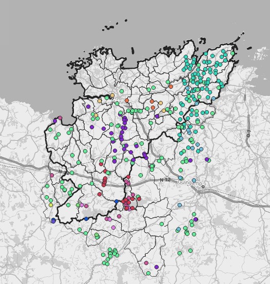
Points de métamorphismes sur le territoire de LTC
Points de métamorphismes sur le territoire de LTC
Simple
- Alternate title
-
SQE
- Date (Publication)
- 2022-01-14
- Edition
-
Points de métamorphismes sur le territoire de LTC
- Edition date
- 2022
- Purpose
-
Visualiser les différents points de métamorphismes sur le territoire de LTC
- Status
- Completed
- Point of contact
-
Organisation name Individual name Electronic mail address Role Lannion-Trégor Communauté
Service Geomatique
support.sig@lannion-tregor.com
Custodian
- Maintenance and update frequency
- As needed
- Maintenance note
-
Les points de suivi peuvent évoluer chaque année.
- Theme
-
-
Hydrologie
-
-
Registre de thème INSPIRE
-
-
Géologie
-
- Use limitation
-
Usage libre sous réserve des mentions obligatoires sur tout document de diffusion : "Source : Lannion-Trégor Communauté"
- Use limitation
-
Licence ouverte : https://www.etalab.gouv.fr/licence-ouverte-open-licence
- Access constraints
- Other restrictions
- Use constraints
- License
- Other constraints
-
Pas de restriction d’accès public
- Spatial representation type
- Vector
- Denominator
- 25000
- Language
-
fre
- Topic category
-
- Environment
- Description
-
Lannion-Trégor Communauté
))
- Reference system identifier
- EPSG:3948
- Topology level
- Geometry only
- Geometric object type
- Point
- Distribution format
-
Name Version WMS
1.3
WFS
1.0.0
- Distributor contact
-
Organisation name Individual name Electronic mail address Role LANNION-TREGOR Communauté
Service Geomatique
sig@lannion-tregor.com
Publisher
- OnLine resource
-
Protocol Linkage Name OGC:WFS-1.0.0-http-get-capabilities
https://georchestra.lannion-tregor.com/geoserver/opendata/ows? opendata:vm_geologie_geo_harm_p_divers
OGC:WFS-1.0.0-http-get-capabilities
https://georchestra.lannion-tregor.com/geoserver/opendata/wms? opendata:vm_geologie_geo_harm_p_divers
- Hierarchy level
- Dataset
Conformance result
- Date (Publication)
- 2022-01-01
- Explanation
-
Non évalué
- Pass
- No
- Statement
-
Numérisé sur orthophoto au pas 20cm (2015, 2018, 2021) et 5cm (2021)
Metadata
- File identifier
- fa284d64-0334-4d9f-b1b4-26b31e59eaf8 XML
- Metadata language
-
fre
- Character set
- UTF8
- Hierarchy level
- Dataset
- Date stamp
- 2026-03-25T14:23:02.657189709Z
- Metadata standard name
-
ISO 19115
- Metadata author
-
Organisation name Individual name Electronic mail address Role Lannion-Trégor Communauté
Service Développement, Data et Géomatique
sig.support@lannion-tregor.com
Custodian
Overviews
Spatial extent
Provided by