Geocatalogue LTC
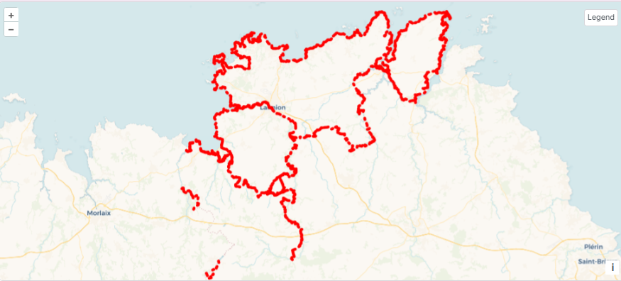
Itinéraires de randonnée GR® sur Lannion-Trégor Communauté
Ensemble des itinéraires de randonnée GR® sur Lannion-Trégor Communauté
Simple
- Alternate title
-
Randonnée pédestre
- Date (Publication)
- 2026-03-13
- Edition
-
LANNION-TREGOR Communauté
- Edition date
- 2026
- Status
- On going
- Point of contact
-
Organisation name Individual name Electronic mail address Role Lannion-Trégor Communauté
Service Geomatique
support.sig@lannion-tregor.com
Custodian
- Maintenance and update frequency
- As needed
- Theme
-
-
randonnée
-
tourisme
-
pédestre
-
-
Registre de thème INSPIRE
-
-
Mobilité
-
- Use limitation
-
Usage libre sous réserve des mentions obligatoires sur tout document de diffusion : "Source : Fédération Française de Randonnées Pédestres
- Use limitation
-
Les sigles GR® GRP® PR, ainsi que les signes de balisages correspondants (blanc/rouge, jaune et jaune/rouge), sont des marques déposées par la Fédération Française de Randonnées Pédestres.
- Access constraints
- Other restrictions
- Use constraints
- License
- Other constraints
-
Pas de restriction d’accès public
- Spatial representation type
- Vector
- Denominator
- 25000
- Language
-
fre
- Topic category
-
- Location
))
- Reference system identifier
- AUTO:42001
- Reference system identifier
- AUTO:42002
- Reference system identifier
- AUTO:42003
- Reference system identifier
- AUTO:42004
- Reference system identifier
- AUTO:97001
- Reference system identifier
- AUTO:97002
- Reference system identifier
- AUTO:97003
- Reference system identifier
- EPSG:27572
- Reference system identifier
- EPSG:2000
- Reference system identifier
- EPSG:2001
- Reference system identifier
- EPSG:2002
- Reference system identifier
- EPSG:2003
- Reference system identifier
- EPSG:2004
- Reference system identifier
- EPSG:2005
- Reference system identifier
- EPSG:2006
- Reference system identifier
- EPSG:2007
- Reference system identifier
- EPSG:2008
- Reference system identifier
- EPSG:2009
- Reference system identifier
- EPSG:2010
- Reference system identifier
- EPSG:2011
- Topology level
- Abstract
- Geometric object type
- Curve
- Distribution format
-
Name Version WMS
1.3
WFS
1.0.0
- Distributor contact
-
Organisation name Individual name Electronic mail address Role LANNION-TREGOR Communauté
Service Geomatique
sig@lannion-tregor.com
Publisher
- OnLine resource
-
Protocol Linkage Name OGC:WFS-1.0.0-http-get-capabilities
https://georchestra.lannion-tregor.com/geoserver/opendata/ows? opendata:vm_itineraire_gr
OGC:WMS
https://georchestra.lannion-tregor.com/geoserver/opendata/wms vm_itineraire_gr
- Hierarchy level
- Dataset
Conformance result
- Date (Publication)
- 2025-01-01
- Explanation
-
Non évalué
- Pass
- No
- Statement
-
Numérisé sur orthophoto au pas 20cm (2015, 2018, 2021) et 5cm (2021)
Metadata
- File identifier
- c2c90180-fc37-44eb-924d-28f48f5c19f0 XML
- Metadata language
-
fre
- Character set
- UTF8
- Hierarchy level
- Dataset
- Date stamp
- 2026-04-30T10:24:32.162092729Z
- Metadata standard name
-
ISO 19115
- Metadata author
-
Organisation name Individual name Electronic mail address Role Lannion-Trégor Communauté
Service Développement, Data et Géomatique
sig.support@lannion-tregor.com
Custodian
Overviews
Spatial extent
Provided by